South Kaibab Trail – Grand Canyon National Park, Arizona
February 9th, 10th and 11th, 2010
The Grand Canyon. One of the seven natural wonders of the world. Right up there with Everest, Victoria Falls and the Great Barrier Reef. To be there is to understand why. Like you, I had seen all the usual photos and videos that try and capture the amazing views on a small frame, and just like everything else, the real thing is something entirely different. And yet, even though standing in person on the rim is an incredible experience, it's almost as "limiting" as a photograph. In my opinion, if you really want to get some sense of the dimensions involved, you should hike to the bottom. I say "some sense" because even with the hike, the Grand Canyon's size is still something that can't quite be comprehended. Everything is so vast and large that distances and proportions are constantly having to be reordered as you move along. What looks small turns out to be something much larger. What looks close is much further. Rarely do we have views of such a wide and expansive setting. I believe this is part of the reason our sense of space can be so misleading out there. If you want to feel like you are shrinking into the world around you, go down the Grand Canyon.
Being the last and most anticipated expedition of our great southwest adventure, Peter and I had tried to time our arrival at the Grand Canyon to match up with some predicted fair weather. Driving from Page, AZ to the South Rim, we encountered a few different weather systems, but by the time we arrived the weather was looking sketchy. Cold, cloudy and snowy. We soon realized that our initial plan to tent it in Mathers campground would not quite work out, as there were several feet of snow covering everything and we weren't even sure if it was accessible. Plus, with all the cozy lodges on the Rim calling to us, it wasn't hard to change our plans. We decided to check out Bright Angel Lodge for availability and lucked out with a room for $90. At the same time we inquired about possible vacancies at Phantom Ranch, since our attempt to reserve a spot a few weeks before had failed (note to anyone wanting to stay at the ranch... try to reserve up to a year in advance, because apparently that's what people do). Well, as fortune would have it, there had in fact been a cancellation and Peter and I were able to rent an entire 10-person cabin to ourselves for $114. We also chose to purchase the steak dinner ($40) and morning breakfast ($20) to limit the amount of food we'd have to carry. All was working out splendidly.


The rest of the day was spent eating, preparing our gear, gift shopping, admiring the view and chuckling at the sounds coming from the room next door. We woke up in the dark at 6am the next morning and hunted down the Maswik Lodge through the cold, thick fog. This lodge is the only one that serves breakfast at that time, which was good for us since we were catching the 8am shuttle to the trailhead. All went according to plan and we soon found ourselves riding the free shuttle bus with a group of about 6 other hikers. By the time we arrived at the South Kaibab trailhead (30 minute bus ride from Bright Angel Lodge), the sun was shining in a beautiful sky. I was feeling incredibly lucky for another perfect day. By 8:30am we were making our way down the first set of snow-covered switchbacks on Kaibab and admiring the "grand" view before us. Though it is advised to use crampons in this section during winter (which can be purchased in the shops on the rim), my hiking boots and poles provided plenty of grip all the way through. Speaking of which, this was my first hike using two poles and I can honestly say it made a big difference for me, both in terms of balance and strength left in my legs and knees by the end of it.


A group of fellow hikers from Kentucky, New Hampshire, Quebec and Ohio, started down the trail with us and we all couldn't help but pause every few moments to snap pictures and admire the stunning views. I have always found it interesting how easy it is to strike up conversations with complete strangers while outdoors. What is it about it that creates this friendly atmosphere? Are we all just invigorated and feel the need to communicate it, or is it more about a desire to group together when travelling in more extreme environments? I wondered how long we'd hike as a group. Turned out not too long, since we all had different paces and eventually spread apart along the trail.


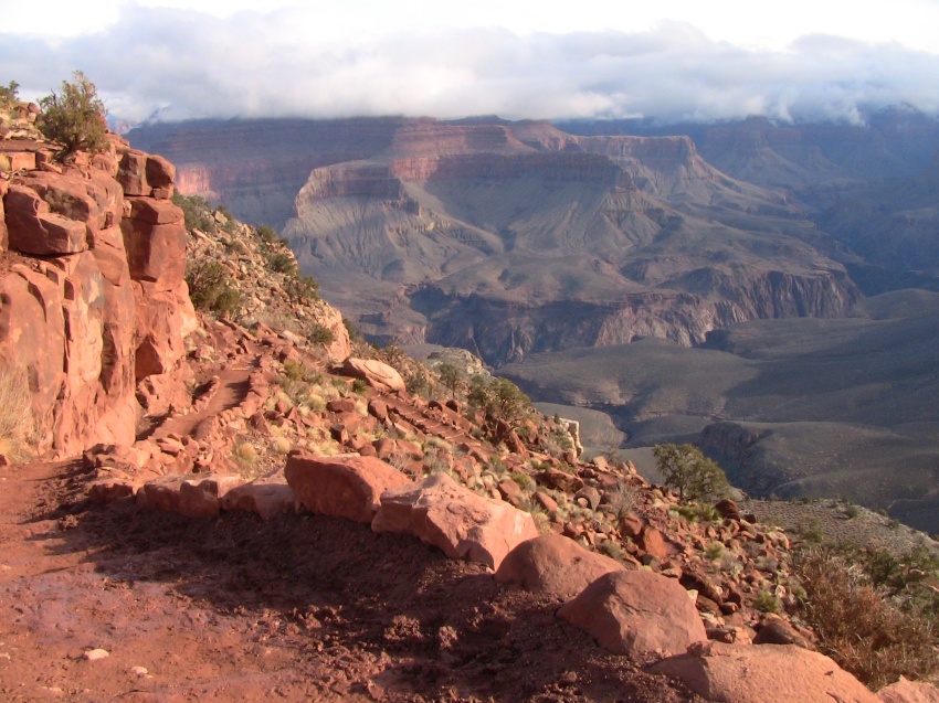
Even though I was constantly being awed by the views around me as we made our way down towards Cedar Ridge, I was also easily distracted. This is always something that concerns me about these experiences. As much as I want to enjoy and "soak in" the views surrounding me, I still end up feeling a bit oblivious to it all. It seems like I'm always in my head trying to manage an endless stream of distracting thoughts. I guess this is just typical of our everyday human experience, but I wish I could develop a more meditative form of hiking. Although, I know from previous extended hikes, the more gruelling and longer it lasts, the more the movement, pacing, breathing and focus naturally creates a kind of meditation. Maybe that is even one of the key reasons I love hiking so much. Of course, there is little to complain about, for I was in the Grand Canyon after all, and unlike so many other hikes I have done, this time I was not suffering from any joint issues whatsoever. Also, unlike all the other hikes, I had the benefit of starting from the top which allowed me to take in the views at my peak energy level (though, being exhausted at the top of a climb has its benefits too). The 1.5 mile stretch of trail down to Cedar Ridge was a great start for us. We arrived at about 9:20am and took a little break to chat with a scruffy looking young man who had been doing work on the trail for the last 2 weeks and was finally heading out. He would be the first in a long series of young trail workers making their way out of the canyon, most looking quite exhausted. Though we found this slightly humorous, we knew it would be our turn soon enough.


The next 1.5 miles to Skeleton Point took a little less than an hour and included some easier flat trail sections and excellent views of O'Neill Butte. Also, the trail was losing its snow cover and beginning to have some muddy sections to avoid. Along the way we passed a group of elderly hikers, which was proof that anyone prepared and willing can do this hike... not to suggest it's an easy hike, not in the least! In fact, during the summer months, hundreds of people need to be rescued every year due to exhaustion and they are usually young, fit men (according to the warnings we read). I just want to make it clear that one should not underestimate the Grand Canyon, as we would come to realize on the way out.


Looking down from Skeleton Point you get a perfect view of one of the more gruelling sections of the trail (when hiking up). Before you is a long series of switchbacks winding their way down a steep hillside. Everyone we passed coming up this section were more winded and obviously feeling it... even the mule train we passed were given several breaks on their way up. Without a word, Peter and I were both considering how tiring this section would be for us the following day. It is certainly one of the hardest parts of South Kaibab trail coming up and it also happens to be very close to the halfway point (which is listed on the only mileage sign post of the entire trail). One thing Peter and I both noticed as we pulled out our cameras to take pictures of the passing mules was that we got the distinct impression that the Native Indian lead riders did not want their pictures taken. I'm not sure if this had to do with a belief system (I've heard that some believe a photo steals their souls) or more of a general annoyance with all the "tourists" taking their pictures every day. So just a heads up.


Heading down the switchbacks obviously wasn't much of a challenge, as long as I ignored the fact that every step down would equal one up the following day. But for now, there were views to take in, desert air to breathe and photos to take. After the switchbacks the trail levels out for quite a while, eventually leading to the second washroom area and Tonto Trail junction (1.4 miles from Skeleton Point). We arrived there at about 11:15am and took a break to eat some lunch. We both still had plenty of water, but I imagine that during the summer months the amount we brought would have been inadequate, especially if we were packing a lot of gear down as well. Since we had food and shelter waiting for us at Phantom Ranch we were travelling very lightly, which is always a good thing in my opinion.


Fifteen minutes later we were back on the trail, anxious to complete our final push to Phantom Ranch. As a side note, a few hundred meters further along the trail is an emergency phone (The Tipoff), though if you have a cell phone there seems to be some coverage as well.
One of the interesting things about this section of the trail is that we could clearly see the edge of the "final" canyon into the Colorado River. We had been looking at that "crack" in the lower canyon floor ever since we started on the rim and imagined that once we reached it we'd basically be there. However, making our way to the edge and finally getting a clear view into the "crack" revealed it to be something much larger and deeper than we imagined. And so it is with everything in the Grand Canyon.


You do get a sense that your journey now has an end in sight because this is the point where you finally get your first glimpse of the Colorado River, but at the same time you realize there is still a ways to go. There are some amazing lookout points along this section and stunning views of the trail stretching on in the distance. Eventually you reach the longest set of switchbacks, which thankfully lead to the Black Suspension Bridge and a true sense that you are near the end. Again, heading down these "endless" switchbacks was not a big deal, but coming up the following day was quite an eye opener, to say the least. Getting to the bridge (through a short tunnel in the rock) felt great. It almost had the feeling of entering through a gateway of sorts... representing a transition in your journey from raw, untamed nature to human engineering and modification. Ugly or beautiful? A matter of opinion I suppose, but nonetheless welcoming for weary human travellers. Having hiked 2.2 miles from the Tipoff phone, we were finally across the bridge by 1pm and leisurely making our way along the river bed towards the turnoff for Phantom Ranch.


Along the way you pass by the remains of a 1,000 year old Anasazi Pueblo. This and the 2 billion year old rock walls around you almost force you to contemplate time and how truly short a human life span is. What is 100 years when compared to the age of the stones beneath your feet? What multitude of events have transpired through the history of these canyon walls? We are not only small in size but also in time within this incomprehensible world wonder. It is almost intimidating sensing the hard and absolutely massive amount of rock surrounding you... us with our soft, small, fragile bodies. I suppose this is why it is called a "wonder"... it inspires a deep questioning of what our place in the world is.
Just a short jaunt from the end of the bridge you reach the junction for Phantom Ranch/Bright Angel Campground and the Bright Angel trail. We headed up towards the Ranch following the little stream and soon came across a very tame deer. We passed by Bright Angel Campground, which looked like it had some nice spots to camp right beside the stream. By 1:20pm we reached Phantom Ranch and the end of the day's journey.


Registering at the main office/dinner hall, we were given keys to our cabin, which was close by and filled with bunk beds waiting to support our tired bodies. What can be better than stretching out on a soft bed after a long hike? How about a huge feast? In the meantime I spent some solo time back down by the river's edge listening to music and contemplating a hopeful future. This was my chance to finally meditate on my surroundings. I truly felt at peace and joyful.


At Phantom Ranch dinners are strictly scheduled and because we had ordered the steak dinner, we had the luxury of being fed first at 5pm sharp. It was a packed house! The dinner hall is arranged with long table rows and you are assigned a row when you enter. This setup gives you plenty of opportunity to socialize with your fellow hikers and realize how small the world is (I was sitting next to a couple from Montreal... a relatively short drive from where we live and also later met a man from a small town I lived in for 3 years). The dinner consisted of a large tasty steak (no choice on how it's cooked), peas, corn, salad, baked potato (with sour cream and butter available), corn bread, coffee, tea, iced tea, water and a piece of chocolate cake. No one was left feeling hungry from what I could tell. The hosts were friendly, helpful and very efficient. After dinner I took a hot shower in the shared wash house and was pretty much ready to crash for the night.

The next morning Peter and I woke up much earlier than needed... though they serve breakfast at 6am, we had already booked ours for 7am thinking we'd want to sleep in. We killed the time discussing our futures and making commitments to try and create more meaningful lives through the doldrums of our work routines. Later we had a good American style breakfast, the coffee really standing out for some reason. By 7:45am we had refilled our water containers and were heading out of Phantom Ranch. Unlike everyone else heading back up, we chose to return the way we had come as opposed to the standard Bright Angel trail route (which isn't as steep but has more mileage).

Obviously the hike out is a completely different experience from the hike in and this is why there are so many warnings not to try and do the whole canyon in a single day. It's a constant uphill slog for 7 miles and there is no giving up if you want to get out. It's not like every other climb I have done... I always had the option to stop and turn around. Not here.
As we made our way up those first set of brutal switchbacks after the bridge I started to remember all those tired and discouraged looking faces I saw the day before... and I now understood. This was only the very beginning and my heart was pumping like mad. Peter was feeling it too. It was hard to find our pace and rhythm. This section seemed to take forever and was exhausting. To know there were many miles to go felt discouraging, but as we came out of the switchbacks it felt like I had found a comfortable rhythm. For Peter it was a different story. He never felt like he was able to find his rhythm and found the entire hike incredibly difficult (not that I noticed... he wasn't obvious about it). I believe that having two hiking poles made a big difference for me as I was able to use my arm muscles to push myself forward like a skier. I highly recommend them now.


We made sure to take many breaks to catch our breath and drink water (which we were now going through much more quickly than the day before). By the time we had finally reached Cedar Ridge we were ready for a lunch break. There was a strong, cold wind blowing which didn't make our break very comfortable. I was anxious to get out of the wind. Peter was discouraged and tired looking. It was during these final 1.5 miles that he began to feel sick and needed to take an extended break. From his description, it sounded exactly the way I felt on White Mountain Peak... I wondered if he could be suffering from altitude sickness, though it didn't seem like we were high enough. After about 10 minutes, which for him seemed like much longer, he got up and pushed on, eventually reaching those final snowy switchbacks... and sweet bliss. 5 hours from when we started, we were on the rim again. Quite the pace considering it took the same amount of time going down!
Once at the top, Peter automatically began to feel better. We took photos and exchanged congratulations while waiting for the shuttle bus to come by (passes every 15 minutes). And with that, our southwest hiking adventures together were complete. It won't soon be forgotten.
Hike Information
- Distance: To Phantom Ranch and back via the South Kaibab trail is about 14.2 miles (22.85km) round trip
- Time: 5 hours to Phantom Ranch and 5 hours back up to the rim
- South Rim elevation: 7,260 feet (2,212m)
- Colorado River elevation: 2,418 feet (737m)
- Elevation loss/gain: 4,839 feet (1,475m)
For more detailed distance calculations, elevations and a list of features along the South Kaibab Trail, check out the Wikipedia page.
GPS Coordinates (NAD83/WGS84)
- Start of South Kaibab trail: 36° 3' 12.13"N, 112° 5' 1.12"W
- Cedar Ridge and first set of washrooms: 36° 3' 50.46"N, 112° 5' 21.21"W
- Skeleton Point: 36° 4' 52.84"N, 112° 5' 25.21"W
- Second set of washrooms and Tonto Trail junction: 36° 5' 25.95"N, 112° 5' 18.07"W
- Emergency phone (approx.): 36° 5' 27.93"N, 112° 5' 21.77"W
- Suspension bridge over Colorado River: 36° 6' 1.50"N, 112° 5' 19.85"W
- Phantom Ranch / Bright Angel Campground: 36° 6' 20.49"N, 112° 5' 41.06"W
Comments